

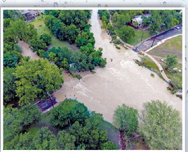
Catastrophic rains midweek that raised water levels even higher than during the deadly July Fourth floods last year kept regional first responders busy with frequent rescues while some areas had to evacuate.
At one point, meteorologists said the Guadalupe River near Comfort crested at close to 37 feet — one more than last year — as torrential storms swelled the channel, forcing officials to urge residents from Boerne all the way to Schertz to leave their homes and seek higher ground.
Warnings were also in place for the Guadalupe River and other Hill Country waterways; the unremitting storms forced Kerrville, Bandera and Comfort residents to brace for disruptions and most of Uvalde was cut off, officials said.
By the weekend, the forecast holds little to no chance of rain, with the National Weather Service showing a 10% chance of rain Saturday and 0% Sunday.
On Wednesday, as the intensity of the storms increased over a wide swath of the Hill Country and a tornado touched down on San Antonio’s far North Side during rush-hour traffic, damaging The Rim along Interstate 10 West, Gov. Greg Abbott spoke about the emergency situation eerily reminiscent of last year’s disaster about the same time.
“We are dealing with and responding to a flood that is likely going to break records,” Abbott said in a prepared release. “There are over 1,300 state personnel from more than 30 agencies that are already activated. More than 800 vehicles, more than 75 boats, and 20 aircraft have been deployed. Our primary focus right now and throughout the remainder of this torrential rain is saving lives.”
The governor remarked that rains up to 29 inches fell on the region last July, but this time levels reached possibly an inch more.
As of deadline, Abbott reported one loss of life but did not specify where.
Closures and evacuations
On Wednesday, when the rains picked up, Boerne saw several road closures and emergency personnel rushing to offer aid.
The Herff-River Road intersection filled with raging rapids as water 2 and 3 feet deep swept down River Road and inundated the intersection by 9:30 a.m., severing a main passage to town along Texas 46 East into Boerne.
As rains diminished and the water receded, roads reopened and city cleanup crews went to work, said city spokesman Chris Shadrock.
Boerne has several lower-water crossings that routinely flood during heavy rains. All but two had reopened by July 21.
At a Wednesday press conference, Boerne Police Chief Steve Perez said dispatchers logged 109 requests for service, resulting in 36 rescue calls, including three vehicle rescues in high water.
“All of this started a little before 8 a.m. We experienced heavy rains until about 2:45 p.m.,” Perez said. “We’ve had a little over 9 or 10 inches of rain in our area.”
At the time, the rain pushed Cibolo Creek up and out of its banks to a record 22.63 feet at the gauge at the Cibolo Nature Center.
Perez said response teams moved 53 people to the Boerne Independent School District central office, which was being used as a shelter during the day, he said, Of those 53, 30 were evacuated from The Trails at River Road Apartments. The chief said evacuation began early enough that people were still able to drive and get out of the property on their own.
“But floodwaters rise quickly and we got to the point where we could no longer get to those folks,” he said. “We were getting reports that water was coming in through some of the first-floor apartments. So, we were telling them just to get to higher ground.”
Boerne was hit with 4-6 inches of rain on July 13, Shadrock said, saturating the ground enough that city officials knew that if they got much more precipitation, they would see the potential for flooding.
The additional rains fell Wednesday, and the waters rose. But the city was ready, Shadrock said.
“A front was headed our way with the potential for record rainfall. That gave us a head start,” Shadrock said. “Our emergency crews began staging and were ready to go. Its swift water rescue team was on standby, geared up and waited.”
That preparation “allowed us to collaborate and anticipate the need, so we were not scrambling when the water began to rise,” Shadrock said.
Preparation
The Boerne Utilities Department and Streets and Parks staff, he said, were primed for service they knew was likely to come.
City leadership reached out to its community partners, the Boerne ISD and the Kendall County Emergency Management team among them, “to make sure everybody was on the same page,” he said, producing “a coordinated, timely response focused on protecting lives and property.
“By sharing information, coordinating resources and making decisions, we have been able to respond quickly as conditions changed rapidly,” he added.
Even as the floodwaters diminish, Perez urged motorists to pay attention to road barricades blocking traffic.
Many were removed once the rains stopped falling and floodwaters receded to allow traffic to resume a natural flow, he said.
“Obey the barricades, don’t go around them. They are there for a reason,” he said.
Street crews and officers will remain in the field as long as needed, assessing road damage and clearing debris.




Comment
Comments